Measure directly in your 3D point cloudsno software to install
Take measurements, calculate distances and annotate your 3D scans up to 500 GB, directly in your browser.
No credit card required · No commitment
mm
Millimeter-level accuracy
Reliable measurements for surveys and inspections
0
Installation required
100% browser-based, on any device
8
Compatible scanner brands
FARO, Leica, Trimble, Viametris, Riegl, NavVis, Matterport, GeoSLAM
Why surveyors and BIM managers measure with ATIS.cloud
Extracting measurements from a point cloud shouldn't require expensive software, a week of training, and a high-end workstation. ATIS.cloud turns point cloud measurement into a point-and-click operation, right in your web browser.
Distance, surface, and angle measurement directly in the 3D app
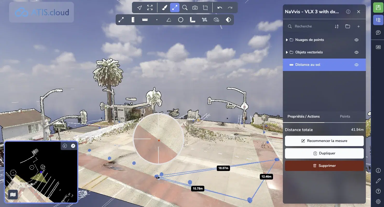
No more switching between your 3D scanner and desktop software. Select the measurement tool in the online 3D app and click on the points you need. Point-to-point distance, surface area, angle: measurements appear instantly on your point cloud data. Perfect for quick site measurements, dimensional inspections, or preparing renovation estimates.
Millimeter-level accuracy on your point cloud data
Your measurement quality depends on your point cloud quality, and ATIS.cloud preserves the full accuracy of your capture data. Whether your scans come from a static laser scanner (Leica RTC360, FARO Focus), a mobile scanner (NavVis VLX), or UAV-based photogrammetry, the platform renders every spatial point faithfully.
Compatible with every scanner: FARO, Leica, Trimble, Viametris, Riegl, NavVis, Matterport, GeoSLAM
You're not locked into a single vendor. ATIS.cloud imports and processes point cloud files from all major 3D scanner and LiDAR technology manufacturers. This compatibility covers standard data storage formats: E57, LAS, LAZ, RCS, RCP, and LGSx.
Annotate and document your measurements
Measuring is one thing. Documenting and sharing is what turns data into decisions. Add dimensions, comments, and visual markers to your scans. Every annotation is saved and accessible to your entire team. Share your measurements and annotations with clients, subcontractors, or project owners, without them needing to install anything.
Scan vs. BIM model comparison (Advance plan)
For BIM managers, ATIS.cloud goes beyond basic measurement. The Advance plan lets you overlay your point cloud (as-built reality) with your BIM model (design intent) for rigorous compliance checking. Visually identify deviations between the digital twin and the physical structure. The essential workflow for clash detection, as-built verification, and construction progress tracking.
Sovereignty in 22+ countries, GDPR / CCPA compliant, SSL encrypted
Your measurement data and point clouds are hosted closest to you, on secure servers in 22+ countries with SSL encryption. ATIS.cloud is fully GDPR / CCPA compliant, a critical requirement for government projects and construction data where confidentiality matters.
How to measure your point clouds in 3 steps
You don’t need to be an expert in point cloud data processing. With ATIS.cloud, measurement is accessible to any professional in construction, surveying, engineering, or mapping.
Create your account
Sign up in seconds and access the platform. ATIS.cloud handles files up to 500 GB and supports the most common formats: E57, LAS, LAZ (Standard plan), RCS, RCP, LGSx (Advance plan).
Upload your point cloud
Drag and drop your point cloud file into the platform. Your cloud is processed and optimized automatically for smooth browser-based visualization. Select the measurement tool that fits your need: point-to-point distance, surface area, or angle.
Share with your clients
Click directly on points in your cloud to place your measurements. Dimensions display in real time on the 3D scan. Annotate, save, and share your measurements and annotations with your team and clients. No software install needed on their end either.
What types of measurements can you take from a point cloud?
A 3D point cloud is a digital representation of the physical environment, composed of millions (or even billions) of points, each with X, Y, Z coordinates. Every point carries accurate spatial information, making it possible to extract reliable measurements directly from the capture data.
Point-to-point distance measurement
Select two points and instantly get the Euclidean distance. Ideal for wall-to-wall dimensions, door openings, ceiling heights, or structural clearances. Millimeter-level accuracy with a static laser scanner.
Surface area measurement
Delineate a zone on your point cloud to calculate the area of a facade, floor, or roof. Essential for area calculations, material quantity estimates, and renovation assessments.
Annotation and dimensioning
Annotate and save every measurement directly on the 3D cloud. Build a complete set of dimensions shared in real time with your team, no third-party software needed.
BIM model comparison (Advance plan)
Overlay your point cloud with your BIM model to measure deviations between design and as-built. Essential for compliance checking, clash detection, and as-built documentation.
Expected precision by capture type
Your measurement accuracy depends directly on the quality of your source data.
| Capture type | Typical precision | Use case |
|---|---|---|
| Static laser scanner (FARO, Leica, Trimble) | 1-2 mm | Interior surveys, compliance checking, as-built |
| SLAM scanner (GeoSLAM, NavVis) | 10-30 mm | Fast building surveys, large space mapping |
| Drone LiDAR | 20-50 mm | Topography, quarries, linear infrastructure |
| Drone photogrammetry | 30-100 mm | Facades, roofs, heritage sites, construction progress |
ATIS.cloud preserves the native precision of your data. Measurements in the 3D app reflect exactly the quality of your capture.
All supported point cloud file formats
File format compatibility is a decisive criterion when choosing point cloud measurement software. ATIS.cloud supports standard formats from all major 3D scanner and LiDAR technology manufacturers.
| Format | Extension | Required plan |
|---|---|---|
| E57 | .e57 | Standard |
| LAS | .las | Standard |
| LAZ | .laz | Standard |
| RCS | .rcs | Advance |
| RCP | .rcp | Advance |
| LGSx | .lgsx | Advance |
Using a scanner not listed here? As long as it exports to one of these standard formats, your data is compatible. And with point cloud files up to 500 GB, even dense point clouds from high-resolution 3D laser scanning campaigns are fully supported.
ATIS.cloud vs. traditional measurement software
Historically, measuring in a point cloud meant investing in expensive desktop software, keeping it updated, and training your team. Here’s how ATIS.cloud compares to traditional solutions.
| Criterion | Desktop software (ReCap, Cyclone, CloudCompare) | ATIS.cloud |
|---|---|---|
| Installation required | Yes, heavy software (several GB) | No, 100% browser-based |
| Online measurement | Yes | |
| Share measurements | No (file export required) | Yes, easily |
| Works with all scanners | Partial | FARO, Leica, Trimble, Viametris, Riegl, NavVis, Matterport, GeoSLAM |
| BIM comparison | Yes (some) | Yes (Advance plan) |
| Annotation | Varies by software | Yes, built into the 3D app |
| Sovereignty / GDPR / CCPA | Not guaranteed | 22+ countries, GDPR / CCPA, SSL encryption |
| Free trial | No or very limited | No credit card |
CloudCompare is a powerful, free open-source tool, but it requires local installation and has a steep learning curve. Autodesk ReCap and Leica Cyclone are robust professional solutions, but their cost makes them impractical for smaller firms. ATIS.cloud is the accessible alternative: online measurement, no installation, works with every scanner.
For every industry
Discover how ATIS.cloud adapts to your sector.
Surveyors
Deliver your scans to your clients in seconds. They view without installing anything.
BIM & Construction
Compare your point clouds with your BIM models. Detect deviations instantly.
Heritage
Document and share your historic monument surveys with your teams and partners.
Manufacturing
Digitize your industrial facilities and facilitate maintenance and renovations.
What our customers say
Discover why over 2,600+ companies trust us.
"ATIS.cloud allowed us to reduce delivery time by 2 hours per project. Our clients can view scans immediately."2h saved per deliverable
James
Licensed Surveyor, Horizon Surveying
"The interface is intuitive and comparing with our BIM models has become child's play. A real productivity gain."+40% productivity
Sarah
BIM Manager, Arcadia Construction Group
"We were able to abandon our expensive on-premise solution. ATIS.cloud is much more accessible and simpler."Affordable pricing
Michael
Technical Director, Meridian Industries
"Sharing has revolutionized how we work with our clients. No need to explain how to install an application anymore."0 client friction
Emma
Heritage Manager, Atlas Heritage Foundation
Security and compliance
Discover other features
ATIS.cloud goes beyond measurement.
3D Visualization
Explore your point clouds up to 500 GB directly in your browser. Smooth navigation, no installation.
Secure sharing
Share with your clients. They view the 3D scan in their browser, without installing anything.
BIM comparison
Overlay your IFC model with your point cloud to detect deviations.
Frequently asked questions about point cloud measurement
Can’t find the answer? Contact us
Ready to simplify sharing your 3D scans?
Join over 2,600+ companies that trust ATIS.cloud to showcase their point clouds.
Try for freeNo credit card required • Cancel anytime